|
 Status of Benthic Macroinvertebrate Communities and Toxicity of
Sediments in the Eighteenmile Creek Area of Concern.
Status of Benthic Macroinvertebrate Communities and Toxicity of
Sediments in the Eighteenmile Creek Area of Concern.
STATUS:
Completed
The NYSDEC proposes a
collaborative investigation with the USGS to evaluate the current condition
of benthic macroinvertebrate communities and toxicity of bed sediments in
the Eighteenmile Creek Area of Concern (AOC). Benthic-community data
provided by the NYSDEC and sediment-toxicity data provided by the USGS from
inside the AOC will be compared to similar data from non-AOC sites in
Eighteenmile Creek or nearby reference streams (of comparable drainage
areas) to determine if the benthos-BUI designation is appropriate or if the
BUI could be removed in Eighteenmile Creek.

Trophic
Trace Food Web Model
STATUS:
Completed
The goal of
the Trophic Trace Food Web Model was to describe the movement of PCB congeners
from sediment and water exposure sources through the aquatic food web. Surface
sediments were taken from above and below Burt Dam, along with three fish
species. The U.S. Army Corps of Engineers (USACE) Buffalo District indicated
that PCBs in surface sediments are bioaccumulating in benthic invertebrates, and
are likely to bioaccumulate in predator fish and higher trophic levels. The
results of this trophic trace food web model study are generally in line with
the the USACE findings.
Learn More
Legacy
Act Sediment Investigation Project
STATUS:
Completed
The purpose of this project is to further evaluate contamination in
Eighteenmile Creek
sediments. The specific objectives of this investigation are to: Further evaluate the nature and extent of Poly Chlorinated Biphenyls
(PCBs), Chlorinated Pesticides (DDT & DDE), PCDD/Fs, Chromium, Copper, Lead,
Manganese, Nickel, Cyanide, Zinc and Mercury contamination in Eighteenmile
Creek sediment to provide comprehensive data relevant to the migration of
contaminants from upstream source areas; Develop and conduct a remedial alternatives analysis for the remediation
of contaminated sediments within the source area of the Eighteenmile Creek AOC; Commence with the Eighteenmile Creek Protection Program within the source
Area of
Concern(watershed). The program consists of the completion of a Feasibility
Study for the Eighteenmile Creek Corridor Site, various site investigations,
and operation maintenance and monitoring activities at a number of
identified source areas.
Learn More
Eighteenmile Creek Stressed Stream Analysis
Project
STATUS:
Completed
Niagara County Soil and Water Conservation District has been awarded
$25,000 to complete a Stressed Stream (Segment) Analysis for the
Eighteenmile Creek watershed. The funds were awarded by the Finger Lakes -
Lake Ontario Watershed Protection Alliance (FL-LOWPA) and are intended to
identify and/or investigate sources of sedimentation and nutrient loading to
Eighteenmile Creek. The stressed stream analysis is an approach that
identifies impacted sub-watersheds and their associated streams. Within a
watershed, stressed stream analysis is an approach for determining how and
where a stream and its ecological community are adversely affected by a
pollution source or other disturbances. It is a technique that identifies
the sources, extent, effects, and severity of pollution in the watershed.
SUNY Brockport has been identified as the contractor for the project and
field work began in November 2008.
Learn More
Area of Concern Education/Outreach Project
STATUS:
Completed
The overall goal of the project is to educate the public as to encourage
them to protect local water quality resources. Specific goal and objectives
of the proposal include: Roll out a final product (pollutant generator
database) that can be easily accessed by the public and all AOC partnering
agencies; Development & installation of 3 watershed education signs at three
public recreation sites in the watershed; Placement of watershed
identification signage where the creek intersects major road crossings;
Installation of approximately 250 storm drain markers throughout the
watershed; Promote watershed awareness.
Storm Drain Marker Project
Watershed Road Signage Project
AOC Community Education Signage Project
Eighteenmile Creek Agricultural Best Management
Practices (BMP) Implementation Project
Status:
Completed
Niagara County Soil and Water Conservation District has been awarded
$202,743 for projects to protect water quality in the Eighteenmile Creek
Watershed. Best Management Practices to be installed on three farms that are
negatively impacting water quality include: milk center wastewater
treatment, silage leachate management, barnyard runoff management, roof
water management, and a compost system. Projects will be implemented by the
District, then operated and maintained by the farm owners. This assistance
is awarded through the NYS Agricultural Nonpoint Source Abatement and
Control Program (ANSCAP), which serves as a vital component of the State�s
Agricultural Environmental Management (AEM) program and is funded through
the Environmental Protection Fund.
Beneficial Use Impairment Investigation
Status:
Completed
Three potential Beneficial Use Impairments (BUIs) at Eighteenmile Creek,
a Great Lakes Area of Concern (AOC), were evaluated as part of the current
investigation: 1. Existence of fish tumors and other deformities; 2. Status
of fish and wildlife populations; and 3. Status of bird or mammal
deformities or reproductive impairment. To determine whether Eighteenmile Creek is impaired in regard to these
BUIs, a wide range of data was collected from Eighteenmile Creek and an
ecologically similar background creek, Oak Orchard Creek, and the data from
the two creeks were compared. Both creeks are tributaries of Lake Ontario,
are of similar size and surrounding geography, and are subject to water
level fluctuations due to changes in lake water levels. In addition, each
creek has a hydro-electric dam located some distance from their confluence
with the lake. Oak Orchard Creek is not listed as an AOC. Between May and September 2007, the following types of data were
collected
from both creeks for the BUI evaluation: (1) fish diversity, abundance, and
condition;
(2) wildlife (birds, mammals, amphibians) diversity and abundance; (3)
concentrations of polychlorinated biphenyl (PCB) and dioxins/furans in brown
bullheads; and (4) prevalence of external, internal, and liver tumors in
brown
bullheads.
Learn More
Eighteenmile Creek State of the Basin Report
Status:
Completed
A State of the Basin Report was published for the Eighteenmile Creek
watershed. The State of the Basin Report provides a snapshot of the current
condition of land and water resources in the Eighteenmile Creek basin and a
look at the programs and initiatives pursued to preserve and restore those
resources. It also provides a vehicle for establishing a consistent process
of identifying resource needs, priorities, and potential work plans. The
report is a catalyst for increased interagency cooperation and public
involvement, through identification and prioritization of issues and
objectives. The idea of creating a �basin wide� report stems from the
decision to take an ecosystem based approach to address the AOC. This
approach will hopefully enable increased coordination among programs and
individuals.
Learn More
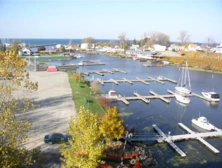
Phase II Habitat Restoration Project
Status:
Completed
In coordination with the Town of Newfane and the U.S. Army Corps of
Engineers, Engineering Research Development Center, the Phase II Habitat
Restoration project has been completed. Approximately 300 lineal feet of
large-rip-rap stone was be placed along the east bank of Eighteenmile Creek
to narrow the channel to its former configuration and to create a low flow
deflector/fishing access wall. Three hundred (300) lineal feet of hydraulic
cover stones were placed along the west bank of Eighteenmile Creek to better
define the channels shape and protect the wetland marsh present along said
bank. Fifty (50) hydraulic covers stones were also be placed in Eighteenmile
Creek for additional in-stream habitat, fish refuge areas, and increased
water flow diversity.
Learn
More
Eighteenmile Creek PCB Source Track-Down Project
Status:
Completed
The purpose of the trackdown project was to further evaluate
contamination in
Eighteenmile Creek sediments. The specific objectives of the investigation were
to: Review all available historical sampling data to identify potential PCB
sources
and future sampling locations of interest, using geographic information
system
(GIS) technology to accurately depict the data spatially; Further evaluate
the nature and extent (horizontally and vertically) of PCBs, arsenic, copper, chromium, lead, zinc, and mercury contamination in Eighteenmile Creek sediment that has the potential to negatively impact the downstream
Area of Concern (AOC); and Assist and make progress towards de-listing
Eighteenmile Creek as an AOC.
Learn More
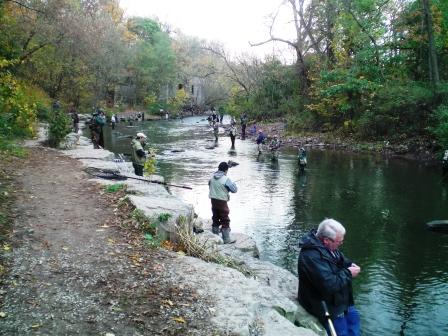
Angler Survey: Analysis of Angler Awareness of
Eighteenmile Creek Area of Concern Fish Consumption Advisory
Status:
Completed
Niagara County Soil and Water Conservation District (NCSWCD) was awarded
funds by the Great Lakes Research Consortium to complete the research
proposal, Angler Survey: Analysis of Angler Awareness of Eighteenmile Creek
Area of Concern Fish Consumption Advisory. Some unknowns currently exist. First, it is important to numerous
stakeholders to determine how many anglers are aware that a fish consumption
advisory exists for the creek. Second, numerous government agencies at all
levels are interested in the need for signage along Eighteenmile Creek.
Third, it is of interest to determine how well the current pathways of
communicating fish consumption advisories work. Currently, fish consumption
advisories are available in a NYSDOH document entitled, Health Advisories:
Chemical in Sportfish and Game booklet. They are also available in the NYS
Department of Environmental Conservation fishing regulations guide.
Learn More
A Comparison of Non-market Approaches in
Determining the Benefits of Remediation at a Grea Lakes Area of
Concern- Eighteenmile Creek, Niagara County, NY
Status:
Completed
In coordination with the Town of Newfane and the U.S. Army Corps of
Engineers, Buffalo District, an angler survey for the Eighteenmile Creek AOC
has been completed. The survey intended to determine the benefits associated
with angler expenditures at Eighteenmile Creek, as well as assess how the
stream�s designation as a Great Lakes AOC impacts angler use. 127 �face to
face� interviews with Eighteenmile Creek anglers were completed.
Learn More
Sediment Modeling for the Eighteenmile Creek
Watershed, Niagara County
Status:
Completed
The Soil Water Assessment Tool (SWAT) was implemented for the Eighteen
Mile Creek watershed to determine annual sediment yields and critical source
areas of erosion in the watershed. SWAT is a public-domain, GIS-based,
spatially-distributed, dynamic model that can simulate watershed-scale
hydrology and water quality processes. The landuse-landcover GIS layer, an
important input for SWAT, was manually updated using 2002 DOQQs. Core data
layers required for SWAT implementation were downloaded from the EPA BASINS
web site. A 10m DEM available from the NY State GIS Clearinghouse was used
to characterize the watershed boundaries in SWAT. The STASGO soils database
was used to describe soil parameters for the model. Drainage network for the
watershed was defined using the National Hydrography Data (NHD) layer. Model
simulations were performed for the period 1992-2004. Weather data for model
simulations was downloaded from the online NCDC web site.
Learn More
Eighteenmile Creek Comprehensive Watershed Management Plan Concept
Document
Status:
Completed
In 2004, a Comprehensive Watershed Management Plan Concept Document was
published for the Eighteenmile Creek watershed. The purpose of this report
is to provide a document specific to Eighteenmile Creek that will lay the
foundation for initiating the watershed planning process, and will provide a
framework for developing a CWMP for the Eighteenmile Creek Watershed. This
Concept Document also presents: existing watershed information for
Eighteenmile Creek, which will support the early stages of the planning
process; guidelines, based upon literature sources, for the development of
the other components of a CWMP, which will serve as a framework for a future
Eighteenmile Creek CWMP. This document has been prepared to: Provide readily
available information that specifically applies to the Eighteenmile Creek
watershed; Provide an overall framework for a CWMP that can be followed once
the planning process begins; and offer example text to demonstrate the
content of specific sections of the Eighteenmile Creek CWMP, once a plan is
developed (i.e., Watershed Management Actions).
Learn More
Caution - LARGE FILE
|